
 Coast to coast, a trip across the United States | Erie Canal
 Coast to coast, a trip across the United States | Brooklyn Bridge, New York City
 Coast to coast, a trip across the United States | Brooklyn Bridge, NYC
 Coast to coast, a trip across the United States | Brooklyn Bridge
 Coast to coast, a trip across the United States | Erie Canal, 1890
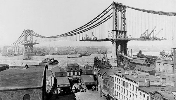 Coast to coast, a trip across the United States | Manhattan Bridge construction
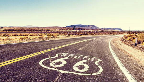
 Coast to coast, a trip across the United States | Historic Route 66
 Coast to coast, a trip across the United States | Historic Route 66
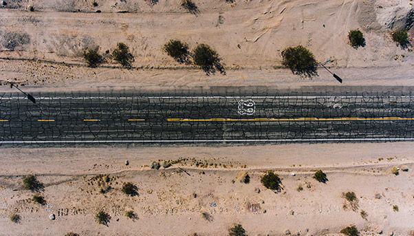
 Coast to coast, a trip across the United States | Route 66
If one day a traveller decided to follow in the footsteps of Woody Guthrie, the undisputed folk minstrel of America, and cross the United States far and wide to tell its story, he would have many more epic ballads to sing. Certainly the traveller would have to pay homage to an infinite expanse of nature – from endless prairies to sumptuous wheat fields, from massive mountain ranges to dramatic ocean shores that Guthrie described in his classic anthem “This Land Is Your Land”.
But our traveller would also have to pay homage to the equally vast number of public works built. Guitar — or laptop — on their shoulder, they would describe new feats of engineering and industrial innovation, from dams and tunnels to cross-county highways and majestic bridges. A network of gigantic infrastructure works that began in the 1800s, then saw a decisive push during the New Deal and after World War II. Although some parts are starting to show their age, this network of infrastructure still represents the connective tissue of this enormous country, as they still do. The works often triggered intense discussions about priorities. The U.S. civil engineering association ASCE calculated in 2017 that the country needed to invest some $4.5 trillion to 2025 to guarantee the maintenance and upgrading of its existing infrastructure. The work to be done would follow a tradition that marked the rise of the United States in the last century. It is here that “We Build Value” begins its coast-to-coast trip of the United States in a two-part series looking at some of the most iconic infrastructure works. Our trip begins on the East Coast.
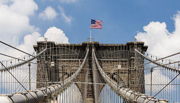
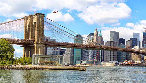
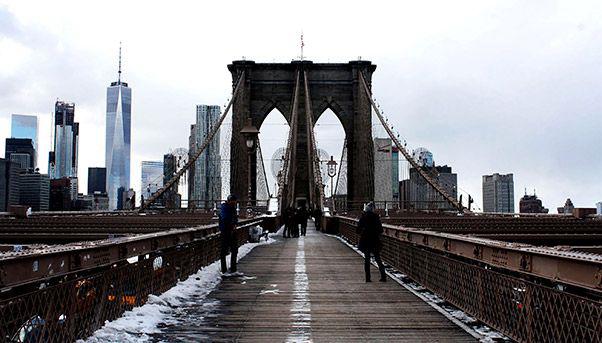
The Brooklyn Bridge
A journey “on the road” is as quintessentially American as apple pie. And where else could it start but on the East Coast, from New York City? The Brooklyn Bridge is perhaps even more of a city landmark than the Statue of Liberty. Connecting Manhattan and its downtown financial centre – with the World Trade Center rebuilt after the tragedy of September 11, 2001 – to the thriving borough of Brooklyn, this cable-stayed bridge is suspended over the East River, 486 metres in length and a maximum height of 84 metres. Started in 1869 and finished 14 years later, it is among the oldest bridges in the country able to accommodate road traffic. It is also the first in the world to be made using steel cables. It is easy to see why it has been a national monument since 1964.
New York is also home to some of the most important projects in the works, primarily in transport. The Gateway Program will redesign railways and tunnels between New York and New Jersey, across the Hudson River, for a total investment of $7.5 billion. The modernisation of the gigantic Port Authority bus terminal and La Guardia airport is expected to cost $8 billion. And the renovation of the John F. Kennedy International Airport terminals is under way at a cost of billions.
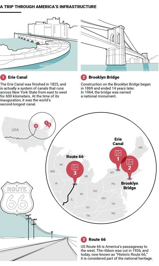
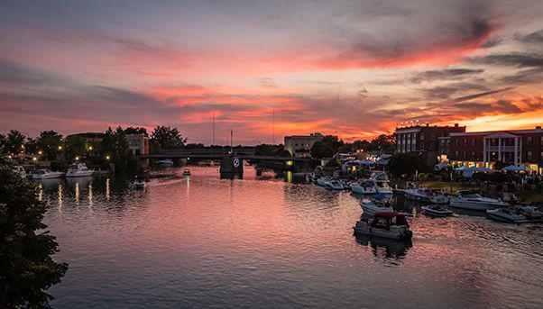
The Erie Canal
The state of New York is the birthplace of one of the first pieces of infrastructure that changed the face of the country. The Erie Canal was an essential part of that New York State Canal System which, in its glory days, stretched from east to west for nearly 600 kilometres, flowing through rural areas. This system connected the state capital of Albany with Buffalo on Lake Erie across from Canada. It took advantage of Albany’s position on the Hudson River to link the city of New York and its port on the Atlantic Ocean with the Great Lakes and the industrial heartland in the Midwest. Completed in 1825, the Erie Canal at the time was the second longest in the world behind the Grand Canal in China. This navigable waterway became a pillar of economic growth. Its crucial role in the country’s development was recognised in 2000 with the designation of the canal as the Erie Canalway National Heritage Corridor. It was also recognised for the phenomenal engineering behind its construction.
Route 66
Just as the Erie Canal connects the East Coast with the Midwest, another piece of infrastructure was founded on the same idea. Route 66, also known as the “Mother Road” and “American’s Main Street,” is the architype of the U.S. highway. Immortalised in novels, beginning with John Steinbeck’s epic story of the Great Depression “The Grapes of Wrath,” this strip of asphalt was inaugurated in 1926. It went on to become the core of an interstate system that developed after World War II for both civilian and military purposes (to facilitate the transport of troops and armaments in a country as large as the United States). The original Route 66 ran from the skyscrapers of Chicago, west across the Midwest and veering slightly south, linking Missouri, Kansas, Oklahoma, Texas, New Mexico, and Arizona, ending up in Santa Monica, today a prestigious suburb of Los Angeles, California. It was the symbol of long journeys – whether they were voluntary or forced for economic reasons – made by generations of Americans. Over the years it has experienced many changes and reincarnations and in 1985 was removed from the United States Highway System to be replaced by more modern highways. It survives, however, thanks to numerous sections preserved in states such as Illinois and New Mexico with the name of “Historic Route 66,” designated as a National Scenic Byway.
The National System of Interstate and Defense System has its roots in 1916 and World War I. But its shape and its name date from the post-World War II years when President Dwight Eisenhower formalised the system in the 1950s. It was completed 35 years later at an estimated cost of about $500 billion (in 2016 dollars) and today consists of almost 80,000 kilometres of motorways and bridges, moving one quarter of all U.S. motor vehicle traffic.